
Korea Cross-Country Cycling Trip 00 (1) - Getting to Know Q&A
- Jinwook Chang
- May 21, 2025
- 7 min read

Updated: Aug 8, 2025
Here, you can access all the relevant information you need to know before going on the Korea Cross-Country Cycling Tour. We will be here to support you in every step to support you in this adventure across days.
In this blog, I wanted to give more information about the incredible biking journey I took across South Korea—the 국토종주 (Korea Cross-Country Cycling Tour). Covering over 600 kilometers from the northern city of Incheon all the way down to Busan, this trip took me through riverside paths, mountain passes, bustling cities, and quiet countryside. It wasn’t just a physical challenge—it was a full-on adventure, packed with memories, landscapes, and personal growth that I’ll never forget.

I had the privilege to travel to Korea with one of my best buddies—Dingyu Wang—right after my junior AP exams, embarking on a new journey while truly enjoying the post-AP life. We went on the trip for a total of five days, starting in Incheon and finishing in Busan, both completing the trip and receiving certificates and medals.
However, the trip was not just about biking or receiving certificates and medals. It was a journey of growth, a time to reflect and overcome the burnout from a stressful semester filled with AP exams and tight deadlines. Every pedal stroke felt like a reset, as we left behind the academic grind and rediscovered a sense of discipline driven not by pressure, but by passion. It gave me a moment to breathe, to take a true break from work, and just exist in the moment—whether that meant cycling under the blazing sun, savoring ice-cold banana milk at a rest stop, or watching the Han River shimmer at sunset.
The route wasn’t just scenic—it was adventurous and deeply moving, bringing us through rice paddies, mountain passes, and peaceful riverside towns where the natural beauty of Korea came alive. I felt a deeper love for the environment, realizing how much cleaner, quieter, and more connected the world feels when you travel by bike. We met locals who cheered us on, other bikers who shared their stories, and shop owners who reminded us of the warmth of Korean culture. Above all, this five-day journey helped me reconnect with myself. Somewhere between Seoul and Busan, I began to find who I truly am—not just a student, but a traveler, an adventurer, and someone who deeply cares about the world around me.
I hope y'all going on this trip to be able to mark this trip as a turning point in life, whether that is personal growth, overcoming difficulties, or finding who you truly are, and I hope to support you in every possible step, preparing for the trip.
I have collected questions from many cyclists online through the online survey, and here are the answers to your 20 most frequently asked questions:
What is the Korea Cross-Country Cycling Trip (국토종주)?
The Korea Cross-Country Cycling Trip, or 국토종주 자전거길, is a 600+ km national bike route that runs from Incheon/Seoul to Busan, connecting scenic rivers, small towns, and historical sites. It’s a government-backed project aimed at promoting eco-tourism and fitness. The path is well-marked, safe, and mostly separated from cars, making it ideal for both beginners and experienced riders.
Do I need to register or apply to participate?
No registration is required to ride the route. It's open to anyone. However, if you want official certification (a medal and certificate), you need to purchase a cycling passport and stamp it at designated checkpoints along the way.
Where can I get the cycling passport, and how does it work?
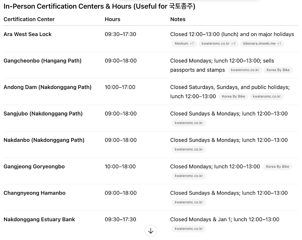
You can buy the passport (about ₩4,000) at bike shops near the start points like Ara Lock (Incheon) or Gayang Bridge (Seoul). At each checkpoint (marked with a red booth), you stamp your passport using the provided ink pad. Once you reach the final checkpoint in Busan, you can submit your passport (not on Mondays) to get an official medal (Additional ₩12,000) and certificate from the Korea Road Traffic Authority.
Make sure to check when each certification closes and opens to avoid mishaps. Most certification centers are unmanned (just a stamp and a booth), but some have workers whom you can reach out to for help. See the image below.
How long does it take to complete the full route?
Most riders complete the journey in 5 to 9 days, depending on pace and stops. Some seasoned cyclists do it in 3–4 days, while casual tourists often take up to 10 days to fully enjoy the scenery, food, and culture along the route. It took my friend and I 5 days, but it was a pretty relaxing journey, so if you do have some experience with biking, you could definitely challenge yourself with a shorter 3 or 4 days trip.
Is it safe to cycle in Korea, especially long-distance?
Yes—South Korea has one of the safest and most bike-friendly long-distance paths in Asia. The routes are well-maintained, mostly separated from traffic, and dotted with rest areas, water fountains, and convenience stores. Solo travel is common, and Koreans are generally helpful to travelers.
What kind of bike should I use?
A hybrid or road bike is ideal, as the paths are mostly paved but can include some hills and gravel. You’ll need a sturdy frame, panniers or a backpack for gear, and good brakes for mountain segments like the Saejae Trail, which includes steep climbs.
Can I rent a bike in Korea for the trip?
Yes, but options are limited for long-distance touring. Some bike rental shops in Seoul or Incheon offer multi-day or one-way rentals (returning the bike in Busan), but it’s best to reserve in advance and clarify logistics. Alternatively, consider buying a used bike if staying longer. You could just buy a cheap second-hand bike for the trip as well.
If you intend to rent a bike, download the app Lycle (라이클), where you can find bike rental shops near your location.
What are the must-see spots along the route?
Highlights include the Ara Waterway, Hangang River through Seoul, Chungju Lake, the mountainous Saejae Trail, Andong's cultural villages, and the Nakdong River wetland parks in Busan. Each stretch has its own vibe—from urban skylines to peaceful farmland.
Where do I sleep during the journey?
Lodging is easy to find. Most riders stay in motels, guesthouses, or minbaks (local B&Bs) near towns and checkpoints. Prices range from ₩30,000–₩60,000 per night. Some budget travelers camp or sleep at public rest shelters, though you’ll need your own gear. Use apps like Trip.com to find models, guesthouses, or minbaks nearby. On the way to your final destination in the certification centers, guesthouses often leave their phone number and poster, so calling to check whether they have room may be a good idea, especially as you approach the south.
Is language a problem for foreigners?
In big cities like Seoul or Busan, many signs are in English and staff may speak basic English. In rural areas, English may be limited, but body language, translation apps, and friendliness go a long way. Many local people are excited to help foreign cyclists on the journey.
What’s the best season to do the trip?
The ideal seasons are spring (April–June) and fall (September–October). The weather is mild, the skies are clear, and the landscape is stunning with cherry blossoms or autumn foliage. Summer can be hot and humid with sudden monsoon rains, while winter may be icy and unpleasant for long-distance riding unless you're experienced in cold-weather cycling.
Is there mobile signal and Wi-Fi along the route?
South Korea has excellent nationwide mobile coverage, even in rural areas. You’ll have a stable signal throughout most of the trip. Free Wi-Fi is available at many convenience stores, rest stops, and cafés. If you’re visiting short-term, getting a Korean SIM card or portable Wi-Fi is recommended for maps, translation, and emergencies.
How do I navigate the route—are maps or apps available?
The entire route is well-signposted, often with blue lines or signs marked “국토종주 자전거길.” You can also use apps like Naver Maps or Kakao Maps, which are more accurate than Google Maps in Korea. There’s also the official Four Rivers app, though it’s mostly in Korean. GPS files are available online for route planning.
Are there places to eat along the way?
Yes, convenience stores (CU, GS25, 7-Eleven) and local restaurants (분식집, 백반집) are frequent, especially near towns and villages. Most sell rice meals, noodles, kimbap, and drinks, and many convenience stores have outdoor seating, water refill stations, and microwaves. You won’t need to carry much food unless going through remote mountain areas.
How physically demanding is the entire trip?
While the terrain is generally flat along the rivers, the Saejae Trail (especially near Mungyeong) includes steep ascents and descents. Completing the full 600+ km journey in several days is definitely a challenge, but with good pacing, proper hydration, and breaks, even moderate cyclists can complete it. Training beforehand helps, especially for longer daily distances.
Can I do parts of the route instead of the full ride?
Yes! Many cyclists choose to do sections of the trail. For example, the Hangang trail in Seoul is perfect for a day ride, while the Nakdonggang trail near Busan offers a scenic two- or three-day ride. You can start and stop anywhere, and there are train stations and bus terminals near most segments for easy transport.
What should I pack for the trip?
Essentials include: helmet, gloves, sunscreen, rain jacket, water bottles, snacks, phone mount, charger, passport (for stamping), change of clothes, and basic repair tools (spare tube, patch kit, pump). You may also want to bring a lightweight sleeping bag or towel for unexpected overnight stays or budget sleeping options.
Are there any rules or cycling etiquette I should know?
Yes—ride on the right-hand side, give way to pedestrians, signal when passing, and don’t blast music without earphones. At narrow spots or bridges, dismount signs may appear—please follow them. Helmet use is required by law, though not always enforced. Also, don’t litter—the trails are kept clean by everyone.
How do I return to Seoul after reaching Busan?
The easiest way is to take the KTX high-speed train from Busan Station to Seoul Station. However, KTX does not allow full-sized bikes unless they’re in bike bags (packed). Alternatives include Mugunghwa trains, which allow unboxed bikes but are slower, or using bike delivery services (택배) to ship your bike back while you return by train.
Is this trip suitable for solo travelers, especially women?
Yes—Korea is one of the safest countries in the world for solo travelers. Many women, including solo female riders, complete the trip without issue. Just as anywhere, stay aware of your surroundings, avoid isolated areas at night, and let someone know your itinerary. Local cyclists and residents are generally very friendly and helpful to travelers.
Also, please x100 download and use an APP called NAVER Map instead. NAVER Map is the predominant map used in Korea, and it has the most accurate GPS and information of the surrounding area.

Comments